Notifications

8 minutes, 2 seconds
-19 Views 0 Comments 0 Likes 0 Reviews
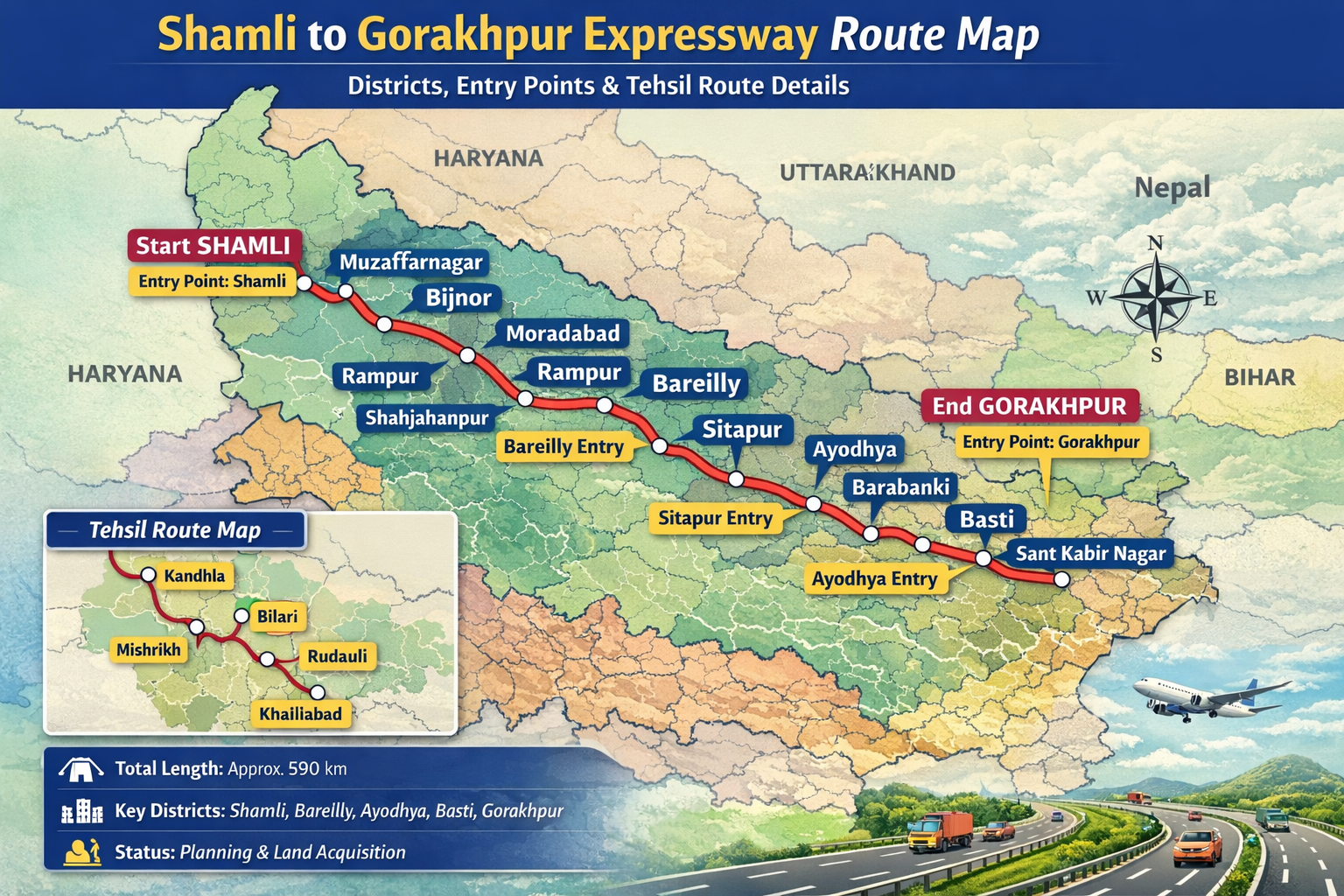
The Shamli to Gorakhpur Expressway is one of the most ambitious infrastructure projects proposed in Uttar Pradesh. This upcoming expressway aims to improve connectivity between western and eastern parts of the state, significantly reducing travel time and boosting economic development. Many travelers, investors, and residents are searching for the shamli gorakhpur expressway map route map to understand which districts, cities, and tehsils will be connected by this important highway.
In this guide, we will explore the gorakhpur shamli expressway route map, districts covered, entry points, and the latest updates about this project.
The Shamli–Gorakhpur Expressway is a proposed high-speed corridor that will connect the city of Shamli in western Uttar Pradesh with Gorakhpur in eastern Uttar Pradesh. The expressway is expected to pass through several districts, improving trade, tourism, and transportation across the state.
This corridor will complement other major expressways in the state and provide an alternative route for travelers moving between western UP and eastern UP.
Key highlights of the project include:
Faster connectivity between western and eastern Uttar Pradesh
Reduced travel time between Shamli and Gorakhpur
Improved logistics and freight movement
Boost to local industries and real estate
The shamli gorakhpur expressway map route map shows how the highway will connect multiple districts and important towns along its route.
The shamli gorakhpur expressway map route map indicates a long east-west corridor across Uttar Pradesh. The expressway will begin from Shamli district and move toward eastern UP, eventually reaching Gorakhpur.
According to initial planning and route proposals, the expressway may pass through the following districts:
Shamli\
Muzaffarnagar
Bijnor
Moradabad
Rampur
Bareilly
Shahjahanpur
Hardoi
Sitapur
Barabanki
Ayodhya
Basti
Sant Kabir Nagar
Gorakhpur
This gorakhpur shamli expressway route map is designed to connect both developed and developing regions of the state.
The route will also intersect with existing highways and expressways, making it easier for travelers to access other parts of the state.
Understanding the district-wise route helps residents and businesses know how the project will affect their areas.
The expressway will begin in Shamli, a district known for agriculture and sugar production. From there, the highway will pass through Muzaffarnagar and Bijnor, connecting important farming regions.
After crossing western districts, the route will move through Moradabad, Rampur, and Bareilly. These districts are major commercial hubs in Uttar Pradesh.
The expressway will continue toward Shahjahanpur, Hardoi, and Sitapur, providing improved connectivity for central UP.
In eastern UP, the highway may pass through Barabanki, Ayodhya, Basti, and Sant Kabir Nagar, before finally reaching Gorakhpur.
The gorakhpur shamli expressway tehsil list map will show smaller administrative regions and villages that fall along the proposed route.
To ensure accessibility, the expressway will include multiple entry and exit points. These interchanges will connect the highway with major roads and nearby cities.
Possible entry points may include:
Shamli interchange
Muzaffarnagar access point
Bareilly junction
Sitapur interchange
Ayodhya connectivity point
Basti entry point
Gorakhpur terminal interchange
These interchanges will make it easier for travelers to join or exit the highway without entering crowded city roads.
The gorakhpur shamli expressway route map will clearly mark these access points once the final route is approved.
The expressway is expected to bring many benefits to Uttar Pradesh.
Travel time between Shamli and Gorakhpur will be reduced significantly compared to current highway routes.
Industries, warehouses, and logistics hubs are likely to develop along the corridor.
The route passes near religious and historical destinations such as Ayodhya, which can increase tourism.
The shamli gorakhpur expressway map route map will connect several national highways and state highways, strengthening the overall transport network.
The Shamli–Gorakhpur Expressway is currently in the planning and proposal stages. Government authorities are studying the feasibility, land acquisition requirements, and environmental impact.
Once approved, the project will move toward:
Detailed route planning
Land acquisition
Construction phases
The final gorakhpur shamli expressway tehsil list map will be released after the route alignment is confirmed.
Infrastructure experts believe the project could become one of the longest east-west expressways in Uttar Pradesh.
The Shamli Gorakhpur Expressway is a proposed high-speed highway that will connect Shamli in western Uttar Pradesh with Gorakhpur in eastern Uttar Pradesh.
The shamli gorakhpur expressway map route map will be available on official government portals and infrastructure planning websites once the final route is approved.
According to preliminary plans, it may pass through districts such as Shamli, Muzaffarnagar, Bareilly, Sitapur, Ayodhya, Basti, and Gorakhpur.
The gorakhpur shamli expressway tehsil list map shows the tehsils and local administrative areas located along the proposed route.
The project is still in the planning stage, so the construction timeline will be announced after final approvals and land acquisition.
The Shamli to Gorakhpur Expressway has the potential to transform transportation across Uttar Pradesh by connecting western and eastern regions with a modern high-speed corridor. The shamli gorakhpur expressway map route map and gorakhpur shamli expressway route map will help travelers, businesses, and investors understand how the project will improve connectivity across multiple districts.
Once completed, the expressway will reduce travel time, support economic growth, and create new opportunities for development along its route. As the project progresses, more details including the final gorakhpur shamli expressway tehsil list map and entry points will become available

